If we find a species and document its presence at a location, then we can say with certainty it occurs there. If we do not find that species, however, it’s a little more complicated: does the species occur there but we failed to cross paths with it on our search, or is this location truly outside of its range? NatureServe uses advanced ecological modeling techniques to develop predictions of where imperiled species are most likely to occur.
Species Habitat Modeling
It’s impossible for our scientists to inventory everywhere. Using the mapped locations of the species we have documented, and data characterizing environmental conditions at those locations, NatureServe develops models that predict where the habitat for at-risk species is likely to be found. The models produce maps of species distributions, which helps rule out places where at-risk species probably don’t occur while directing new field surveys and conservation efforts to places that matter most. Better species distribution maps save time, minimize conflict, and make conservation more efficient.
Click the button below for a deeper exploration of the science behind our species habitat modeling
Species Habitat Modeling Dashboard
The dashboard provides detailed information about the status and availability of species habitat models in NatureServe’s model library, allowing users to search for models by species characteristics, conservation status, and geographic distribution. It also provides a link to a metadata document for each model, with detailed information on inputs and methods, recommended model uses, and expert review. NatureServe Network programs can use the dashboard to learn which models have been reviewed by their program, and which models are available in their area for taxonomic groups of interest.
Abiotic Niche Modeling
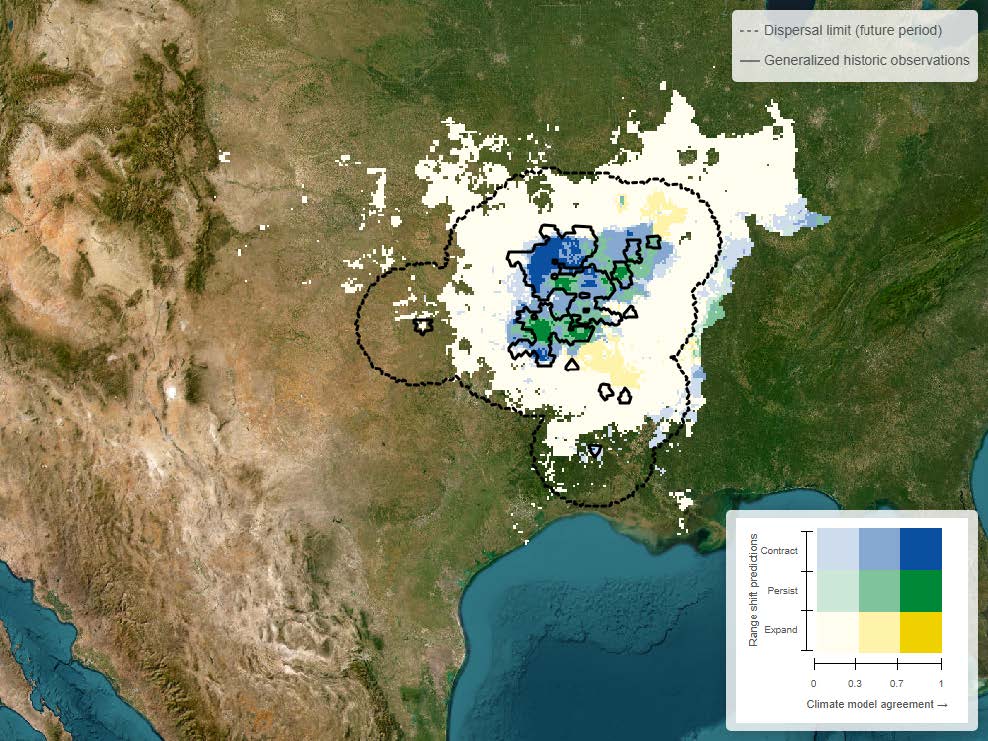
In addition to predicting the distribution of habitats under current conditions, NatureServe has created a workflow for predicting the distribution of suitable climate conditions for at-risk species in the future. NatureServe’s abiotic niche models relate species observations to climatic variables from multiple global climate models (GCMs) to identify areas with suitable climate conditions for species occurrence in historic and future time periods. Abiotic niche models can be used to estimate and compare vulnerability of species to climate change, assess the stability of habitat suitability at a site of interest, and explore the potential for assisted migrations or translocations.
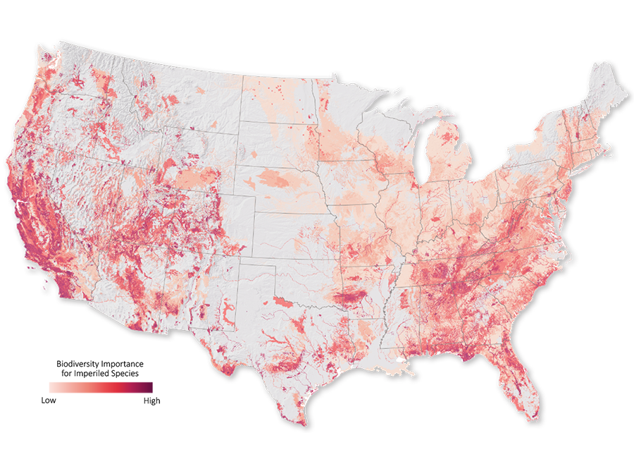
Project Highlight: Map of Biodiversity Importance
A collaborative effort to identify the places most important for conserving at-risk species.
The Map of Biodiversity Importance provides a portfolio of maps that identify areas critical to sustaining our nation's rich biodiversity. Through a landmark collaboration with Esri, The Nature Conservancy, and Microsoft's AI for Earth program, NatureServe and our network of natural heritage programs created a comprehensive set of habitat models for over 2,000 at-risk species in the contiguous United States. We analyzed these models in conjunction with protected areas boundaries to map areas of high importance for conserving vertebrates, freshwater invertebrates, pollinators, and plants. These publicly available products provide an invaluable input to guide effective conservation decision-making.
New in 2024, the Map of Biodiversity Importance has been updated to reflect our current understanding of imperiled species. The Map of Biodiversity Importance 2.0 includes over 500 additional species, including a new group of pollinating insects (solitary bees) and hundreds of species newly identified as imperiled or critically imperiled or listed under the endangered species act. The Map of Biodiversity Importance products are also now at higher resolution: 9X more precise than the original maps.
Project Highlight: OneRange
Refining Habitat Maps for Imperiled Species Via Human-AI Collaboration
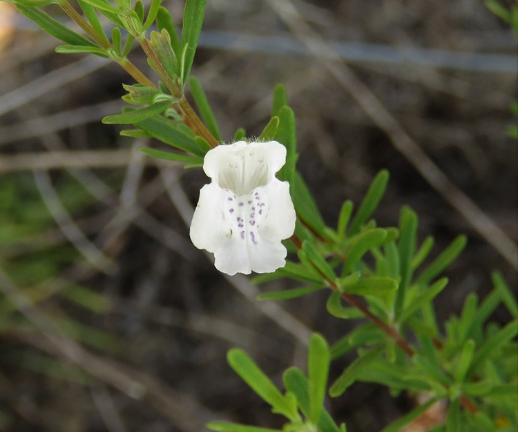
NatureServe partnered with the Fish and Wildlife Service and NatureServe Network member programs in Florida, Georgia, and South Carolina to demonstrate the power of our human-AI collaborative approach for modeling species habitats. This effort, called the 'OneRange project,' created new, refined habitat maps for four endangered species of high conservation conern: Britton bear's grass, Apalachicola false rosemary, fringed campion, and the frosted flatwoods salamander.
This project demonstrates how NatureServe's species habitat modeling process combines state-of-the-art AI and expert input. This collaborative approach could result in better refined, robust, and transparent species habitat maps for threatened and endangered species to support regulatory activities and improve species recovery outcomes.

Range Mapping
More generalized information on species distributions also helps land managers, scientists, and the interested public understand which species might be encountered in a given area. NatureServe generates range maps, which depict the broad geographic areas in which species are found, using our documented occurrence data and the collective knowledge of our network of expert scientists.
EBAR Range Mapping
NatureServe Canada’s Ecosystem-based automated range maps (EBAR) initiative is developing publicly accessible range maps for priority species.